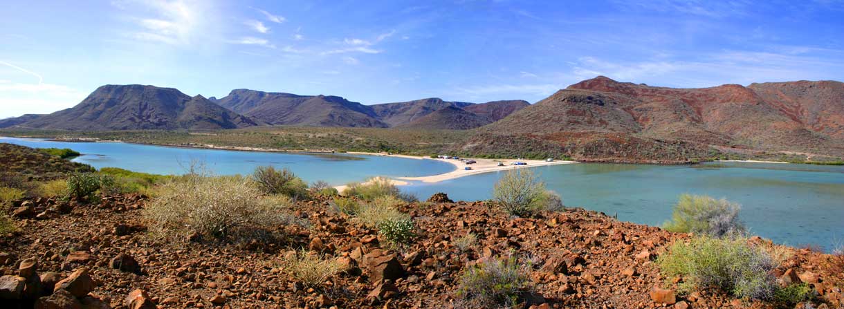
Playa Requeson from the island
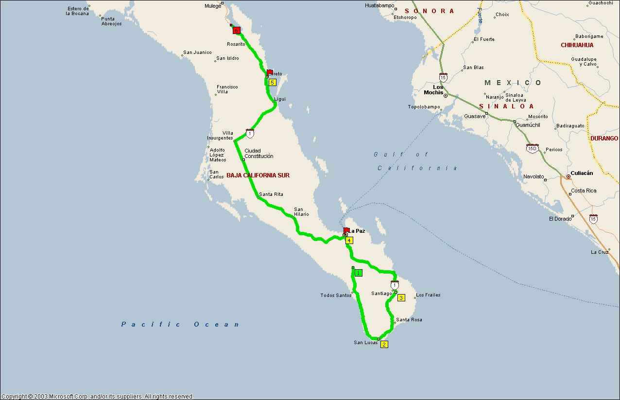
Los Cabos to
Playa Requeson
3/23-25/05
Playa Requeson & Mulege Album
(photos were taken after the Semana Santa crowd left)
Once I got into the outskirts of San Jose del Cabo, where the road was still 4 lane but traffic had thinned out, I discovered something else; the small urban buses don’t exceed 20 mph, no matter what. I was in the right lane and behind one for about 5 minutes before I realized that there wasn’t any traffic in front of him.
Ever since entering the Baja, I’ve seen Café Combate signs on coffee shops. Well, I finally looked it up. Combate means “out of the competition” so I guess Café Combate is a rest stop from the rat race. I don’t know if it’s a chain but every town seems to have one. Some of them are pretty run-down looking so it may just be a common term down here.
ROAD REPORT:Just past the last airport turn-off, Hwy 1 becomes a narrow 2-lane road again. Oh well, I’m getting used to them. I am now leaving the coast area and heading inland for awhile. The road will briefly rejoin the coast at Los Barriles and then turn into the Sierra Laguna Mountains before crossing a fertile plain and entering La Paz. From La Paz on north is the same one I traveled down so there won’t be any more road reports unless I run across something different.
The irritating thing about topes; You never know how steep or high they’re going to be. You can’t just say “well here’s a tope, I’ll slow down to 15 mph” because some will rattle your teeth at 5 mph and others can be taken at 20 mph.
Approaching and around Miraflores the terrain could be called “badlands” as it is arroyo country. Some of which are extremely large. Of course they don’t span these arroyos with bridges, they just snake the road down one side and back up the other. The old saying, “approach every turn as a hairpin turn until you can see around it” definitely applies here.
When the road rejoins the gulf coast around Los Barriles, it’s just one little seaside village after another, all with their own bunch of topes. All are very picturesque and none has a harbor or marina. The boats are either anchored out or pulled up on the beach. There is numerous inns, hotels, and a few RV parks all along this area. Los Barriles itself is a fairly large community with lots of palm trees, shops and stores. As the Los Cabos area becomes more expensive and crowded, a lot of people are moving up here.
After leaving Los Barriles and the coast behind, the road follows a very large arroyo inland. And I mean large! The cliffs are at least a hundred feet high on each side and the arroyo must be a mile wide at the coast. Of course, the road doesn’t travel along the bottom of the arroyo but is cut into the cliffs on both sides, first one side then the other. About half way up there is a number of dwellings built on top, and cut into the side, of a narrow point that looks out over the arroyo. They appear to be the home of a single family group. The road actually cuts behind this promontory and continues on its way up the side of the cliff.
Near the top is village of San Bartolo. As you enter from the south, the buildings are all on the right side of the road and there is a walkway cantilevered over the cliff face on the left. Farther up, the road finally crests the cliff and the town opens up on both sides.
The road now enters the green, high wooded country of the Sierra Laguna Mountains. This is farming and cattle country. I had to chase cattle off the road a couple of times.
The road leading out of the mountains can be very scary at places. There is a couple of turns where there wasn’t enough room to install a guardrail, the pavement just drops off into the abyss. Of course on my side of the road!
During this whole leg from Los Cabos to La Paz I never saw another RV on the road. And I can understand why. The road through Todos Santos is a much better route to Las Cabos. Every one should drive this eastern route once but, unless your destination is down here, stick to the western route.
From here on, I’ll only be making comments about the roadside sights but no real road report since I’ve covered all this on the trip down. There’s only one highway, remember?
Leaving La Paz, sign says “ Tijuana 1495 km”, that’s about how far I have to go to get back into the U.S.
Another sign for topes, “Reductor de Velocidad”. I don’t know how much more “Reductor” I can get on some of these topes. OUCH!!
Leaving La Paz, I fell in behind a 5er from Montana and at the Military checkpoint outside La Paz we both were waved through. I think it was because the soldiers were busy with 2 buses that they were going through. That’s the first RV’er I’ve seen on the road since I left Los Cabos. I passed the 5er a little later and never saw him again.
Road sign, “ Cancun 13 km”; think it might be another Cancun?
All the way across the Magdalena Plain, I was fighting a 30 km north wind. Since I never seemed to be hitting it straight on, it was a struggle all the way.
Coming down the north side of the Sierra Giganta, at a couple of spots you can look almost straight down and see two or 3 switchbacks below you. I didn’t realize just how steep a climb this was, coming up. Going down my top speed was about 25 mph in second gear. A large semi coming up must have been heavily loaded; he was only doing walking speed with a line of cars behind him. I’m glad I didn’t get stuck behind someone like him when I came up. One of the cars behind that truck must be an alternative fuel vehicle, because all of a sudden I smell french fries.
Loreto again: The Easter Holiday is in full swing here. The town is deserted and the beach is packed. I’m making an overnight stop so I can dump my tanks, hit the bank, and fuel up in preparation for my stay at El Requesón. I’m already topped off with fresh water so I should be OK there.
North of Loreto: Leaving Loreto there is a military inspection station a little north of town. This is the first one that I’ve actually been inspected at. There were 3 soldiers in the coach at the same time. They finally figured out that 4 people was just too many and one got out. They looked in all the cupboards and closets, and the refrigerator/freezer, asked where I was coming from (I said Los Cabos), and if I had any fruit. I showed them a banana, small lemon, and a small lime. They weren’t interested in any of them. We discussed my photos on the walls and, of course, the fishing poles in the overhead. They also wanted to know if I was married. I told them “no senoria, mucho senoritas”. They got a laugh out of that. I’d heard a lot about them coming aboard with their weapons but none of these guys were armed. They all seemed young and bored. I noticed when I pulled up they appeared to be fighting over who got to inspect me. Now that’s really bored!
One thing I really dislike about these roads, when you have to pass a semi on a stretch of road that has no centerline and no fog line. I rely on them to keep my position on the road and without them, I’m really nervous!
Quite a few times now, I’ve come across a man (local) walking along side of the road, out in the middle of nowhere, with a small backpack and a sleeping roll. They are normally decently dressed and clean looking, don’t look like bums and I wonder where they came from and where they are going; and why they are tackling a walk across the desert?
I’ve got the wind to fight again today, about 35 mph out of the north. It’s going to make for a long drive. I’ve also got the livestock. I’ve had to stop twice now for herds of goats. The last one looked like angora goats. I wonder what they are doing, wandering around out in the middle of the desert? I’m just glad they weren’t around a blind curve where I couldn’t see them. I was tipped off about the first bunch by an on-coming car with his emergency flashers on. They do that here if there is some kind of road hazard (or cop) ahead.
I’ve come across quite a few Hummer H2’s down here and surprisingly few are carrying US plates.
PARK REPORT: Well, I’m safely ensconced on the beach at El Requesón, a very picturesque beach on the Bahia Concepción, and it’s still windy as hell. I don’t really understand that name; requesón means cottage cheese! The beach is actually a sand spit that, at low tide, connects the mainland to a small island. So there is campers and RV’ers on both sides of the spit, including on the island end. Of course, those people will have to wait until low tide to get off. Because this is the last weekend of Semana Santa (Holy Week), the place has a good crowd of mostly locals. I see only one other Class A but that doesn’t mean that some of the tent campers aren’t Americano’s. I’ll probably find out tomorrow evening (Sunday) when the locals have to pack up and leave.
There is quite an operation going on here, at least for this weekend. There are ice cream trucks, souvenir salesmen, water and ice trucks, and I don’t know what else being peddled here. There aren’t any hookups of any kind here, in fact, except for the beach and a couple of makeshift pit toilets, there isn’t anything here. Just the way I like it. Now if the damn wind would go away everything would be perfect. If it subsides, I’ll probably stay for about a week. I might even unship my boat.
Well, the wind never did cooperate but it did subside enough for one morning that I was able to wade out to the north mouth of the cove, where there is a sudden drop-off to deep water, and do some fly fishing. I had been watching schools of bait fish jumping to get away from something bigger so I used some fresh water wet flys because I couldn't find my salt water flys. I got a couple of hits but didn't land anything, altho I got a couple close enough to see that they were good pan size fish. I also tried with some spin casting gear and poppers that drew a lot of hits also. I landed 3, released two and kept one to eat. I always crimp down the barbs on my hooks so I can release fish without doing too much damage. I have no idea what they were but the locals said they were good eating so I did. They were catching another type of fish with hand lines on the rocky sides of the island that were also good eating. If I can find my fish ID placard I'll find out what I was eating.
By noon the wind had returned, only now from the south, so it was back to relaxing in the shelter of my RV and some kite flying. I also made a couple of trips to Mulage for shopping, dining, and internet. I also met Bruce from the BajaNomads Forum. I really like this area and am serously thinking about getting a little piece of property down here and putting a palapa on it for a winter homebase. Although I want to check out the Pacific beach area south of Todos Santos and a couple of other areas first.
When the crowd cleared out on Sunday I discovered that there were 3 other RV'ers there, all from British Columbia. Boy, the Canadians really have a large presence down here, compared to the US. More RV'er showed up later in the week, most of them were Canadian also, although there was a couple from Minnesota.
I’m going to have to speed up my return trip. I think something bad is happening to my main slide. It’s dragging one corner to the extent that it has torn up the linoleum. There is either something wrong or maybe something stuck under it. I’m going to stop to check out the Boulder fields around Cataviña and, other than overnight stops, that’s about it. I should be back in Phoenix by April 4 th or 5 th. Since the slides were installed by RV Interiors in Gilbert (a suburb of Phoenix), I’ll take it to them to check out. So, rather than stick around here at Playa Requesón until Bill (Tango Dancer) and his group gets here (they are the ones I’m thinking of going to South America with), I’m heading out now. They won’t be here until April 7th and that’s too late for me if I want to get this slide fixed and still make PA by April 25th.
By the way, Requesón in Spanish means “Cottage Cheese”, I finally figured out why the beach is called that. There are rocks here that are white and look like giant curds of cottage cheese! So it’s Cottage Cheese Beach! I should have taken a picture!
Next stop, an overnight at Guerrero Negro and then on to the Catavina boulder fields.